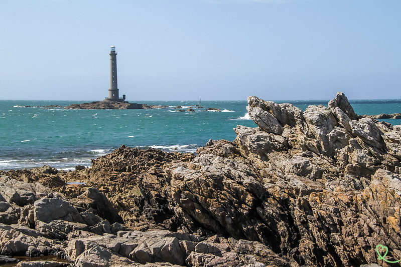
Traveling along the Cotentin Capes route? Stop at the very tip of the peninsula, across from the Hague Lighthouse, also known as the Goury Lighthouse. We were captivated by this granite tower standing in the middle of the sea, at the heart of the Raz Blanchard, one of Europe’s most powerful tidal currents.
Check out this article for our helpful tips—complete with photos —to make the most of your visit to the La Hague Lighthouse!
This guide is completely independent, based on our experiences. We visited the region anonymously, making our own choices and paying our bills in full.
Why Visit the Hague Lighthouse?
Is the Hague Lighthouse worth the trip? Our take:
Yes, the Hague Lighthouse is worth a visit. Even though you can’t go inside, this lighthouse, perched on a rock 800 meters from the coast, offers a striking view. We enjoyed watching it from the small port of Goury, between the lifeguard station and the coastal trail. In rough weather, you’ll see the waves of the Raz Blanchard crashing against its tower.

Why is the La Hague Lighthouse famous?
A symbol of Cap de la Hague, this lighthouse owes its fame to its extraordinary location. According to the Mérimée database (the national inventory of historic monuments), it is the first French lighthouse built on a rock—the Gros du Raz—with a radius of barely 10 meters, isolated at sea 800 meters from the coast. We were struck by the contrast between the massive tower and its tiny base.

Our Favorite Moments
Here are the three moments that left the biggest impression on us in Goury:
- Gaze at the granite tower from the port of Goury, perched on its rock facing the open sea.
- Walk along the coastal trail to the semaphore, with the lighthouse behind you and the sea stretching as far as the eye can see.
- Discover it at every turn along the coastal roads of emr

WHERE TO STAY IN Cherbourg
Option 1: with harbour view
- Mercure Hotel – prices, pictures and availability
- Ambassadeur Hotel – prices, pictures and availability

Option 2: Rest of downtown
- Hotel Le Cercle – prices, pictures and availability
- Hotel Chantereyne – prices, pictures and availability

See our reviews of the best hotels in Cherbourg (coming soon)

Directions and Map: La Hague Lighthouse, Auderville
Where is the La Hague Lighthouse located?
- Off the coast of the port of Goury, in Auderville, a delegated municipality of La Hague (Manche, Normandy)
- Travel time from Cherbourg-en-Cotentin: 35 min
- Travel time from Barneville-Carteret: 1 hour
- Here is a map to help you find your way:
How do I get there?
The easiest way to get to the Hague Lighthouse is by car, since Goury is located at the end of the road, at the tip of the cape.
- By car: From Cherbourg-en-Cotentin, follow the Route des Caps (D901) westward to Goury, a distance of about 29 km (to be confirmed).
- By train: The nearest station is Cherbourg. From there, you’ll need to continue by car
- On foot: The Sentier des Douaniers (GR 223) passes through Goury.
Parking
There is a parking lot in Goury, east of the lighthouse, at the end of the road.

OUR ADVICE FOR RENTING A CAR IN Normandy
- Compare prices on our preferred platform: DiscoverCars – one of the best rated sites.
- Choose a car that is comfortable enough (distances can be long) but compact (some parking lots and villages are narrow).
- Remember to take outcomprehensive insurance (some roads are winding and narrow).
- There is a lot of demand, book it early.
Helpful Tips: Duration, Hours, Food…
Best time to visit
The site can be explored year-round, as access to the harbor and the lookout points remains unrestricted. For the best view, we recommend visiting during the high tides of fall and winter: the waves crashing against the tower create a striking scene. In summer, the longer days are better suited for hikes along the cape. Finally, before you set out, we recommend checking the marine weather forecast, as winds can be strong at the tip.
Duration of the tour and main challenges
Allow about 30 minutes to 1 hour to stroll around the port of Goury, see the lighthouse, and explore the area around the rescue station. If you continue along the loop to the semaphore, plan on about 3 hours for 3 km—which is the duration indicated for the guided tour offered by the Cotentin Tourist Office.

The harbor itself poses no major difficulties. However, certain sections of the coastal trail—particularly between Nez de Jobourg and Goury—involve significant elevation changes: sturdy walking shoes are essential.
Suggested Route
There is no set route, but we suggest you start at the Tourist Office information desk, located in the former lifeboat house. There you’ll find maps and information. Next, head to the SNSM station, then walk to the Croix du Vendémiaire and the pebble beach to view the lighthouse from the front. Finally, we recommend taking the coastal path to the semaphore station and returning via a different route, as suggested by the guided tour.

Visiting with Children
Younger visitors will enjoy seeing the lighthouse rise out of the waves, as well as the lifeguard station, whose ramps lead down to the sea. On the coastal trail, please keep an eye on your children near the rocks and slopes.
Hours and Admission Prices
Access to the port of Goury and the viewpoints overlooking the lighthouse is open to the public and free of charge. The Hague Lighthouse, which has been automated and unmanned since 1990, is not open to visitors.
Visit the official website for more info here.
Guided tours
The Cotentin Tourist Office offers a guided tour titled “From the Pointe de La Hague and Goury, from the harbor to the semaphore.” It recounts the daily lives of the lighthouse keepers, fishermen, and sailors who left their mark on the cape. The 3-kilometer route takes 3 hours and passes by the lifeboat shelter, the Croix du Vendémiaire, the pebble beach, the coastal path, and finally the semaphore. Recommended for ages 8 and up; reservations are required and can be made by calling 0805 32 02 00.
The Port of Goury and Pointe de la Hague, at the foot of the lighthouse
Before you focus on the lighthouse, take some time to explore the small port of Goury. We found it to be both unassuming and steeped in history, with its fishing boats, rescue station, and memorials.

The SNSM Rescue Station
In the heart of the harbor, the SNSM (Société Nationale de Sauvetage en Mer) station immediately catches the eye. Its octagonal shape extends into two launch ramps that slope down toward the sea. We were surprised by this truly unique architecture.
The Vendémiaire Cross and the Pebble Necklace
Just a few steps from the station, the Croix du Vendémiaire pays tribute to the crew of the French submarine Vendémiaire, which sank off the coast in 1912. We paused for a moment in front of this simple monument, which serves as a reminder of just how dangerous these waters still are. Shipwrecks have, in fact, left their mark on the cape’s history: in 1823, 27 ships sank in these waters.

Next, continue toward the pebble beach that runs along the shore. From this beach, we enjoyed one of the most beautiful views of the lighthouse, perched on its rock facing the harbor. Let your gaze linger on the interplay of the currents around the Gros du Raz.

HAVE FUN WITH THESE activities in Normandy
- Helicopter flight over the cliffs of the Côte d’Albâtre
- Book your time to visit Mont-Saint-Michel Abbey
- Take a microlight flight over Mont-Saint-Michel
- Climb the Via Ferrata in Switzerland Normandy

A granite tower on the Gros du Raz
The highlight of the tour, the Hague Lighthouse, can be viewed from the mainland. We spent quite a while looking at this tower, which watches over one of Europe’s most challenging shipping lanes.
The lighthouse stands on the Gros du Raz, a rock separated from the coastline by a channel approximately 800 meters wide. Its granite construction took place from 1834 to 1837, based on plans by engineer Charles-Félix Morice de la Rue. We learned that Morice pioneered a design by moving the staircase to the side of the tower, thereby creating separate rooms and improving the living conditions for the lighthouse keepers.
Standing 52 meters tall, the lighthouse’s beam reaches 19 nautical miles (about 35 km). We are still impressed by such a construction project carried out on the open sea in the 19th century.

Around the Lighthouse: Exploring Cap de la Hague on Foot
The lighthouse is also an excellent starting point for exploring the Cotentin Peninsula on foot. We invite you to put on your hiking shoes and discover landscapes often compared to those of Ireland.
From the harbor to the semaphore tower via the Sentier des Douaniers
From Goury, the GR 223—also known as the “Sentier des Douaniers”—runs along the coast to the La Hague semaphore station. This coastal trail offers unobstructed views of the open sea and the Channel Islands.

The Bunker
On the Sentier des Douaniers (GR 223), between the port of Goury and the La Hague semaphore station, a German blockhouse faces directly across from the La Hague Lighthouse. It was built in 1940 as part of the Atlantic Wall, the line of fortifications constructed by the German army along the coasts of Western Europe.

This specially designed bunker housed a powerful searchlight with a diameter of 150 cm or 200 cm. At nightfall, soldiers would hoist it onto the flat roof via a concrete ramp—which is still clearly visible today—to scan the sea and sky for Allied ships and aircraft.
Toward the Nez de Jobourg
South of Goury, the coastal trail leads to the Nez de Jobourg, one of the most visited natural sites in the Manche department, whose gneiss cliffs rise 128 meters above the sea. There, we discovered a panoramic view stretching from Cap de la Hague to Cap de Flamanville, overlooking the choppy waters of the Raz Blanchard.

Some sections between Goury and the Nez de Jobourg have significant elevation changes: be sure to wear sturdy shoes. Also note that the Jobourg caves can only be explored on guided tours organized by local associations, and access is prohibited from mid-February to mid-July, during the birds’ nesting season.
A Brief History
The lighthouse was built to meet a vital need: to make one of the most treacherous sea passages in the English Channel safer. Here are the key dates to remember:
- 1823: 27 ships sank off Cape de la Hague in a single year.
- 1834: Studies and construction began, based on plans by engineer Charles-Félix Morice de la Rue.
- November 1, 1837: The lighthouse was lit for the first time, with a steady white light fueled by vegetable oil.
- World War II: The lighthouse remained unlit, then was relit following the Liberation in early July 1944.
- 1971: The lighthouse was electrified.
- 1988 or 1989: The lighthouse was automated (to be verified; sources differ).
- 1990: The last lighthouse keepers left.
- 2009: Designated a historic monument.
Frequently Asked Questions
Can visitors tour the interior of the Hague Lighthouse?
The Hague Lighthouse is not open to visitors: it stands on an isolated rock in the sea, 800 meters from the coast, and has been operating automatically since the late 1980s.
Why do we refer to it as both the Goury Lighthouse and the La Hague Lighthouse?
Both names refer to the same structure. “La Hague Lighthouse” refers to Cap de la Hague, the northwestern tip of the Cotentin Peninsula that it marks, while “Goury Lighthouse” refers to the small port across from it, in the delegated municipality of Auderville.
PLAN YOUR TRIP TO Normandy
Inspiration destinations
- Deciding where to go in Normandy – the best destinations
- Our weekend ideas: best-of, romantic, unusual, seaside, luxury, family
- 16 seaside hotels in Normandy
- The most beautiful charming hotels in Normandy

Best of

Practice
- Where to stay in Normandy – best places and hotels
- See our tips for renting a car at CDG airport, Orly airport, Beauvais airport, Caen, Rouen, Bayeux…