The Nez de Jobourg,on the Cotentin Peninsula in Normandy, is a place loved by locals and tourists alike.
Its magnificent landscapes offer high cliffs that have been sculpted by the elements.
Here is our guide to help you plan your visit: map, photos, tips.
Why visit the Nez de Jobourg on the Cotentin Peninsula?
The coastline of the Cotentin Peninsula is wild, raw and beautiful. It offers some of the most beautiful landscapes in Normandy.
And one of the most famous places on the coast is the Nez de Jobourg.
It is very popular with visitors because :
- The cliffs have been eroded by the sea with coves and a promontory
- The views of the coast on a clear day are endless
- The cliffs in the area reach 128m
- It is a protected natural environment with unique flora and fauna that are able to withstand a hostile environment
We really enjoyed it.

More details and photos after the planning tips.
Practical tips and map – Nez de Jobourg, Normandy
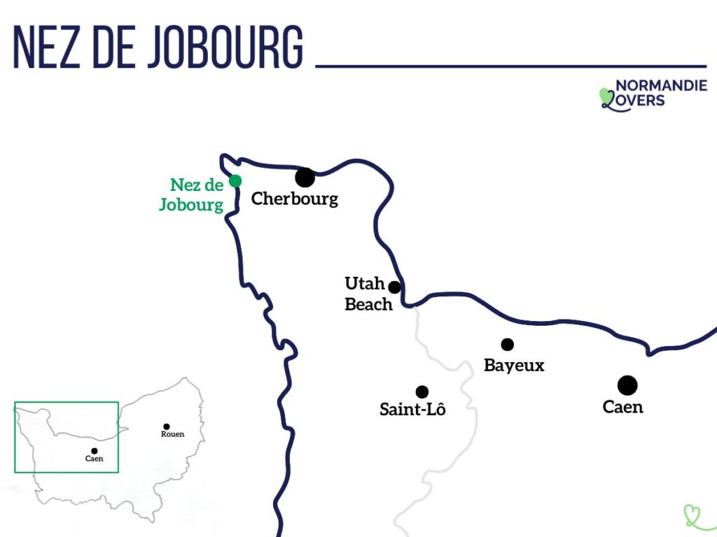
Where is the Nez de Jobourg – Location and map
- Located in the Cotentin peninsula, on its west coast, one of our favorite destinations in Normandy
- Accessible only by car or by hiking on the coastal path
- Cherbourg to Nez de Jobourg = 35min drive
- Saint-Lô to Nez de Jobourg = 1h25 driving time
- Here is a map of the Cotentin Peninsula and its highlights to help you locate the Nez de Jobourg on the west coast:
OUR ADVICE FOR RENTING A CAR IN Normandy
- Compare prices on our preferred platform: DiscoverCars – one of the best rated sites.
- Choose a car that is comfortable enough (distances can be long) but compact (some parking lots and villages are narrow).
- Remember to take outcomprehensive insurance (some roads are winding and narrow).
- There is a lot of demand, book it early.

Tips for your visit
- Allow 30min if you go only to enjoy the view
- Or plan a few hours if you want to explore the area and walk around a bit on the trails
- The access is free
- The parking lot is well marked – it is less than a 10 minute walk from the parking lot to the viewpoint
- Toilets near the parking lot
- A great place to watch the sunset
- It is a very touristic place (second most visited of the department after the Mont Saint-Michel)
- The caves are only accessible through a guided tour, see further in the article.
Nez de Jobourg – Restaurant
There is a restaurant at the viewpoint, theAuberge des Grottes.
You can have a drink or enjoy pancakes on the terrace with a great view.
The restaurant has its own parking lot, but do not park there if you are not eating at the restaurant.

Nez de Jobourg – Lodging
- There is no accommodation at the cliffs.
- You will find very few rentals in the area – see options
- The main city nearby is Cherbourg – see the best rated accommodations in Cherbourg
- Or I recommend a stay on the east coast of the peninsula in Saint-Vaast-la-Hougue, as you can easily make day trips around the peninsula from there – see the top rated accommodations in Saint-Vaast.
- There is no camping at the Nez de Joubourg – the closed campsites are: Camping du Hâble, Caravaning les Eglantines and Camping municipal de Vauville
PLAN YOUR TRIP TO Normandy
Inspiration destinations
- Deciding where to go in Normandy – the best destinations
- Our weekend ideas: best-of, romantic, unusual, seaside, luxury, family
- 16 seaside hotels in Normandy
- The most beautiful charming hotels in Normandy

Best of

Practice
- Where to stay in Normandy – best places and hotels
- See our tips for renting a car at CDG airport, Orly airport, Beauvais airport, Caen, Rouen, Bayeux…

Access and walk to the Nez de Voidries
The place is only accessible by car or by a long walk.
The Nez de Jobourg is located on a tourist route called “Route des Caps”.
The last few hundred meters are on a smaller, but easy to drive road.


There is a large organized parking lot that is well marked.

Nez de Jobourg – walk
Once outside the car, there is no way to get lost.
There is a walking path to reach the viewpoint. It is an easy walk with a slight slope.
If you need a smoother surface, you can also walk on the road leading to the restaurant. However, this is a narrow road, and you will be in the way of other drivers.
It is a part of the famous “Sentier des Douaniers”.

The views only come later in the walk. However, it is short, so be patient.

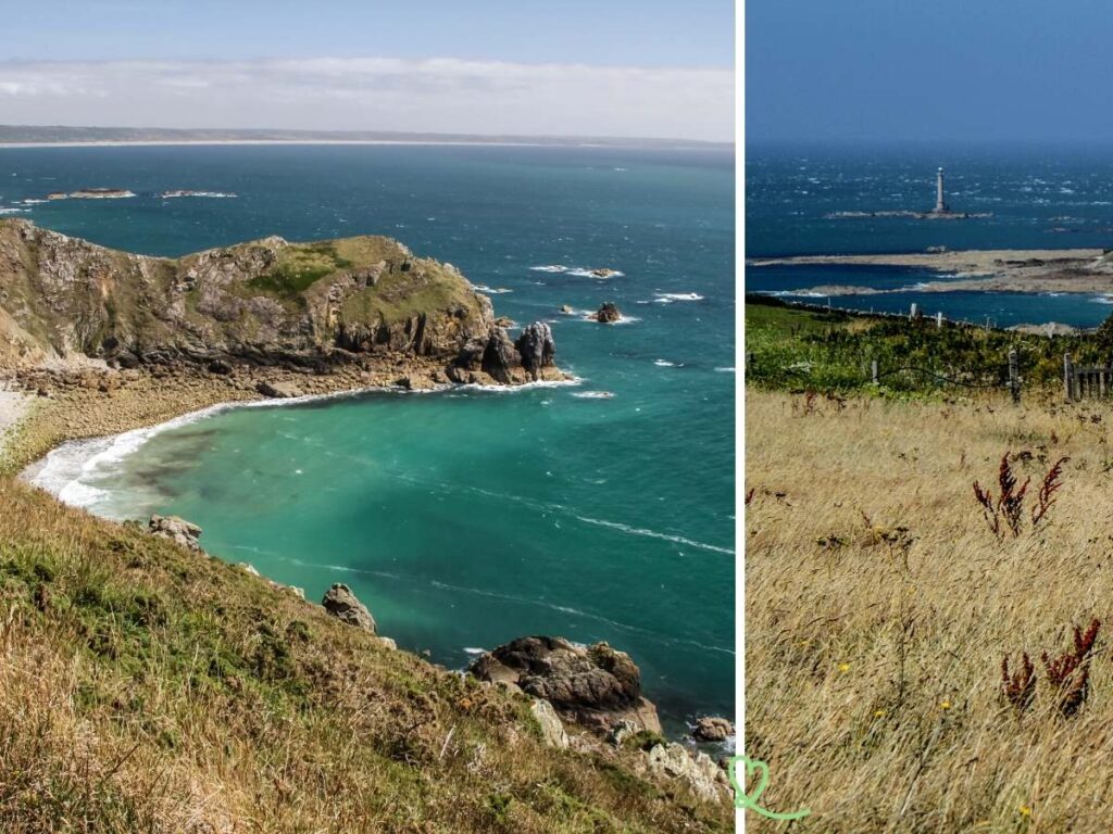
You will first see the views to the right, towards the La Hague lighthouse.

The observation platform is located on another promontory called the Nez de Voidries.
It allows you to have a breathtaking view of the Nez de Jobourg.
USE OUR GUIDE TO PLAN A
DREAM TRIP TO Normandy
All the information you need for your trip:
- 8 maps that make planning easier
- 160+ pre-selected locations
- Practical advice
- 300+ photos to help you choose
Photos of the Nez de Jobourg
And you get to the point of view.
There is a large flat area where you can stand or sit on the small wall to enjoy the view.
You will notice some coves and a rocky promontory.

If you feel up to it, you can also take the walking trail to explore and get different perspectives.
Just be careful if it’s windy (which it often is). The cliffs in the area are very high, reaching 128m. They are among the highest in Europe (but not as impressive as those ofEtretat and the Alabaster coast, in my opinion).
When you walk on the trails, the slopes are very steep.
The strong wind and the breaking waves have sculpted these spectacular landscapes. The prevailing winds are from the west.
The small beaches of the creeks are covered with a mixture of sand and pebbles

.
Depending on the tide, you will be able to see the caves that were dug by the sea. Many legends surround them. The most famous are :
- The “Lions Cave” (Grotte aux Lions)
- Le Trou aux Fées, a small notch in the cliff – legend has it that a tunnel connects it to the church in Jobourg.
- The little church
- The big church
They were used by smugglers to hide their treasures.
The area is steep and unstable, and the access road to the beach was closed in 1960. They can be visited with the associations EXSPEN and“A la découverte de la Hague“.
Subscribe to our Newsletter
- Get away from it all with Region Lovers’ beautiful destinations!
- Once a month
- Advertising-free
Cliffs, geology, history and nature
Most people come simply because it is a wonderful raw landscape where you can see how the elements have impacted the land.
But it is also a place of geological interest.
It is the oldest region of the Cotentin. It dates back to the Precambrian, 2 billion years ago. The cliffs are made of gneiss.

The cliffs of the Nez de Jobourg are home to a wide variety of birds:
- crested cormorants,
- herring gulls,
- the larks,
- meadow pipits,
- spotted warblers
- …
It is a protected area, Natura 2000.

Several archaeological sites have been identified on these cliffs. Flint tools from the Mesolithic era have been found.
There was a semaphore, but it was destroyed during the Second World War.
View to the north – La Hague
From the viewpoint, you can also look in the opposite direction, towards the North.
On a clear day, you can see the lighthouse of Goury, also called the lighthouse of La Hague.
It is 48m high and located on a small rock called “Gros de Raz”.
This lighthouse is essential, because there is a very strong current between the cape and the island of Alderney, only 15 km away. This current is called “Raz Blanchard”. It is one of the strongest in the world, very dangerous for boats.

Do not make
THE SAME MISTAKE WE MADE
On one of our last trips to Europe, a hacker stole our credit card details while we were using a hotel WiFi.
So our trip began with a “card blocked” call… Not funny at all!
Learn from our mistake, make a small VPN investment to surf without worry.

Not far away: Ecalgrain Bay
If you are in Nez de Jobourg, don’t miss the bay of Ecalgrain.
It can be reached on foot or by car.
This is one of my favorite beaches in Normandy and one of my favorite landscapes.
Most people stop at Nez de Jobourg, but it is worth the detour, in my opinion.

If you visit on foot, you will arrive at the southern end of the beach (photo above).
You need good walking shoes. The path includes slopes.
Allow 15min to 30min one way.
And if you arrive by car, or if you feel like walking more, I recommend you head to the cliffs at the north end. The views are beautiful, as you can see in the photo below.

Hiking – Sentier des Douaniers / Sentier du Littoral
The Nez de Jobourg is located on a famous hike called “Sentier des Douaniers” or “Sentier du Littoral” or GR223 (you will see both written on signs).
It is 446 km long between Mont-Saint-Michel and Carentan, following the entire coastline.

